
Mount Everest Explained: Location, Height, Names and How to See the World’s Highest Peak
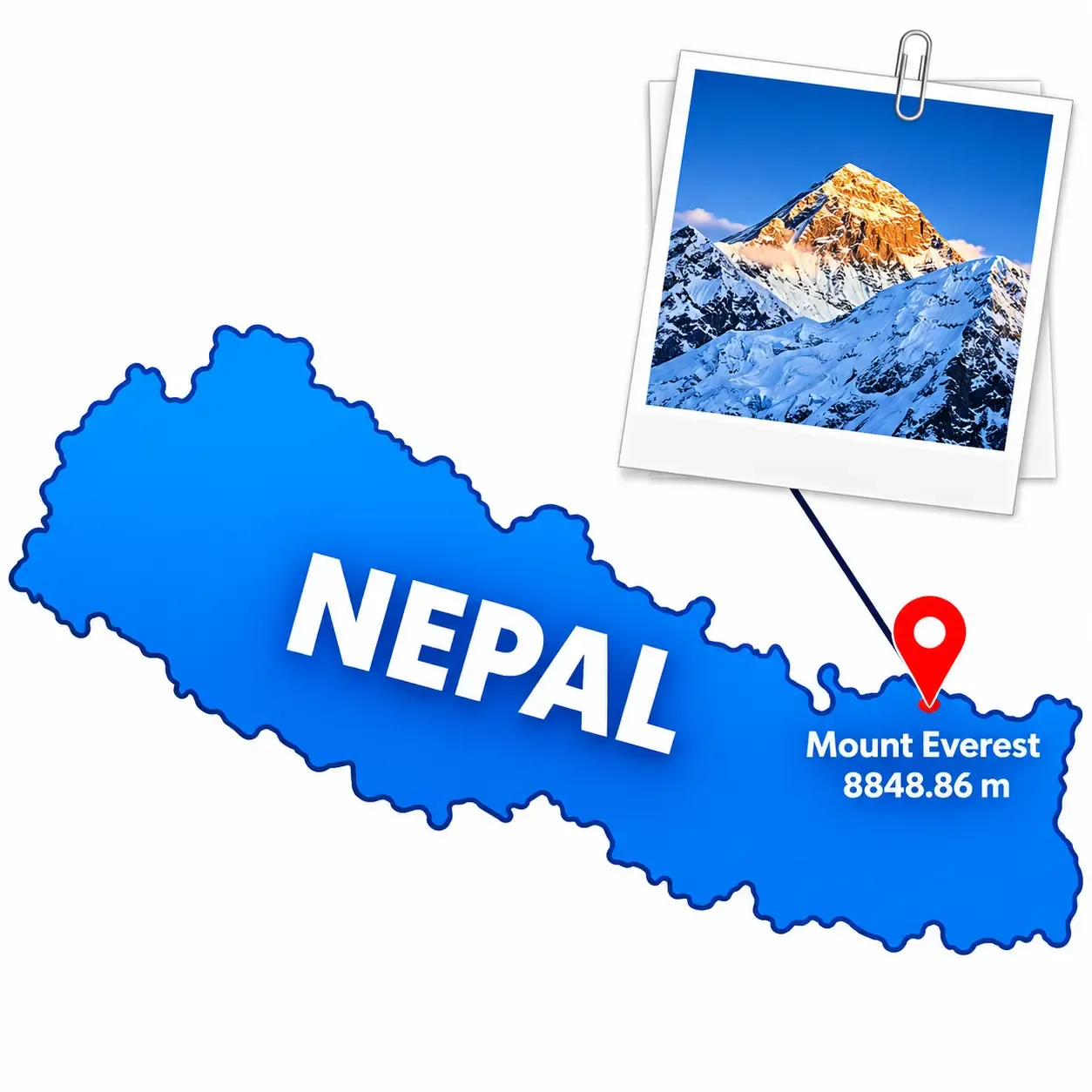
Mount Everest is the highest mountain above sea level, and one of the most recognisable places on Earth. Yet the basic facts are often muddled. Is it in Nepal or China? Is it the same as the Himalayas? Can you see it from Kathmandu? This article sets out the essentials in a clear, practical way, from geography and measurement to history, culture and travel.
Where Mount Everest Is ?
Everest rises in the Mahalangur Himal, a sub-range of the Himalayas in Asia. Its summit sits on the international border between Nepal and the Tibet Autonomous Region of China. Its approximate coordinates are 27°59′17″ N, 86°55′31″ E, or 27.9881° N, 86.9250° E in decimal form.
On the Nepalese side, the mountain lies in the Khumbu region of Solukhumbu District, in Koshi Province, inside Sagarmatha National Park. On the northern side, it overlooks the Rongbuk Valley in Tibet. Because the boundary runs across the summit ridge, the highest point is shared by the two countries rather than owned by one.
People sometimes place Everest in India or Pakistan. It is in neither. Pakistan’s great peak is K2 in the Karakoram, and India’s highest border mountain is Kangchenjunga, which it shares with Nepal. For a fuller breakdown of the geography, coordinates and the Nepal–Tibet border, see this detailed guide on where Mount Everest is located.
The Himalayas and Everest Are Not the Same Thing
The Himalayas are a mountain range more than 2,000 kilometres long, commonly described as crossing five countries: Bhutan, India, Nepal, China and Pakistan. Some definitions extend the range further, so the exact count depends on where the range is said to end. Everest is a single peak within that range, and its highest. Saying “the Himalayas” refers to the whole chain, while “Everest” refers to one mountain.
How Tall Is Mount Everest?
The official height is 8,848.86 metres above mean sea level. Nepal and China announced the figure jointly in December 2020.
|
Measurement |
Height |
|---|---|
|
Metres |
8,848.86 m |
|
Kilometres |
8.84886 km |
|
Feet |
29,031.7 ft |
|
Miles |
About 5.50 miles |
For decades, the commonly cited height was 8,848 metres, taken from an Indian survey in the 1950s. China had published a figure of 8,844.43 metres, which measured the rock height without the snow cap. The 2020 agreement ended that difference by adopting a single shared number.
Modern surveying uses several tools at once. GNSS receivers placed on the summit record its position from satellites, levelling and trigonometry link it to known benchmarks, and gravity data helps define mean sea level, because the sea surface is not perfectly uniform. Teams from both countries made independent measurements before comparing them.
A key point is that mountain height is measured above mean sea level, not from the base of the mountain. By that standard, Everest is the highest. Measured from base to summit, Mauna Kea in Hawaii is taller, and Chimborazo in Ecuador has the summit farthest from the centre of the Earth. Each of those records is real, but Everest holds the one most people mean when they ask about the tallest mountain.
Is Everest Still Growing?
Slowly, in geological terms. The Himalayas formed because the Indian tectonic plate is pushing north into the Eurasian plate. Neither plate sinks easily, so the crust has been crumpled and lifted for roughly 50 million years, and that collision continues.
But the mountain does not rise by a fixed number of centimetres each year. Uplift competes with erosion, glaciers and weathering, and earthquakes can shift the crust suddenly. The 2015 Gorkha earthquake, for example, caused measurable movement across the region. Some research on river changes in the area also suggests that crustal unloading may add a little lift over very long timescales. Changes in the reported height can also reflect better instruments or different reference systems rather than real movement, so scientists describe Everest’s rise as small, uneven and visible only over long periods.
Three Names, Three Histories
The mountain is known by several names, each with its own story.
- Mount Everest. The English name honours Sir George Everest, a Surveyor General of India. After the Great Trigonometrical Survey identified the peak, then called Peak XV, as the world’s highest, Andrew Waugh proposed the name in the 1850s. Radhanath Sikdar, a mathematician on the survey, is widely credited with the calculations. George Everest himself reportedly objected to the name.
- Sagarmatha. This is the Nepali name, popularised in the 1960s and commonly translated as “Forehead of the Sky”. The exact origin of the word is discussed by scholars, so it is best described as a modern national name with strong imagery.
- Chomolungma / Qomolangma. The Tibetan name is long established and is often translated as “Holy Mother” or “Goddess Mother of the World”, though translations vary. It carries real spiritual meaning in Tibetan Buddhist tradition.
Different communities use different names because they came to the mountain through different languages and relationships. Local people knew it long before surveyors gave it a number.
Neighbouring Peaks in the Everest Region
Everest rises among several of the world’s highest mountains, though not all of them touch it. Approximate elevations are:
- Lhotse (8,516 m): connected to Everest by the South Col.
- Nuptse (7,861 m): forms the long southern wall of the Western Cwm.
- Changtse (7,543 m): the “North Peak” next to the North Col in Tibet.
- Pumori (7,161 m): stands near Kala Patthar and is a separate mountain.
- Ama Dablam (6,812 m): a distinctive pyramid that dominates the trail to Tengboche and Dingboche.
- Cho Oyu (8,188 m) and Makalu (8,485 m): farther away along the chain, in separate valleys.
Lhotse, Nuptse and Changtse are directly joined to Everest’s ridges, while the others are nearby or distant neighbours.
A Short Climbing History
British reconnaissance in 1921 explored the approaches from Tibet. The 1922 expedition was the first to use bottled oxygen and reached about 8,320 metres. In June 1924, George Mallory and Andrew Irvine disappeared high on the mountain. Mallory’s body was found in 1999, but Irvine’s was not, and there is no confirmed evidence of whether they reached the summit. That question remains unresolved.
On 29 May 1953, Edmund Hillary of New Zealand and Tenzing Norgay, a Sherpa mountaineer, reached the summit as part of the British expedition led by John Hunt. It is the first widely confirmed ascent, and it ended a three-decade quest.
More milestones followed. A confirmed ascent from the north came in 1960, Junko Tabei became the first woman to summit in 1975, and Reinhold Messner and Peter Habeler climbed without bottled oxygen in 1978. From the 1990s, commercial expeditions grew rapidly, bringing both opportunity and concerns about crowding, safety and the environment.
The Two Standard Routes
There are two main routes to the summit, both finishing at the same point from opposite sides of the border.
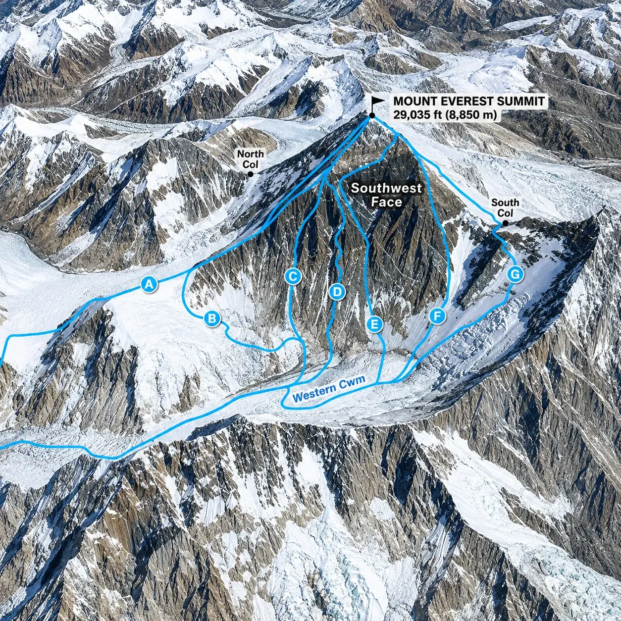
The South Col route begins at Everest Base Camp in Nepal. It crosses the Khumbu Icefall, enters the Western Cwm, climbs the Lhotse Face to the South Col, and follows the southeast ridge to the summit. It is the most commonly used commercial route.
The North Col route begins at North Base Camp in the Rongbuk Valley, which is reachable by road. Climbers go up to the North Col, then follow the North Ridge and Northeast Ridge. The terrain is generally more exposed to wind and cold, and logistics depend on permits and Chinese regulations.
How to See Everest Without Climbing It
Most visitors will never go near the summit, and they do not need to. Several viewpoints offer excellent views:
- Kala Patthar (about 5,545 m): the classic close view of the summit pyramid, especially at sunrise or late afternoon.
- Everest Base Camp (about 5,364 m): the experience of standing at the foot of the route, although the summit itself is hidden from here.
- Gokyo Ri (about 5,357 m): a wide panorama over the Gokyo Lakes, including Everest, Lhotse, Makalu and Cho Oyu.
- Hotel Everest View (about 3,880 m): a comfortable panorama above Namche Bazaar.
- Tengboche: a monastery setting with a dramatic mountain backdrop.
- Everest mountain flight: about an hour from Kathmandu, with aerial views and no trekking required. It is weather-dependent, so schedules can change.
A common question is whether Everest is visible from Kathmandu. Generally it is not, because of distance and the ranges in between. On exceptionally clear days, a few high viewpoints on the valley rim may offer a faint glimpse, but it is not reliable.
Nepal Side or Tibet Side?
Neither side is universally better. The Nepal side is built around the Everest Base Camp trek, which usually starts with a flight to Lukla and then takes several days on foot, passing through Sherpa villages with teahouse accommodation. Most itineraries run around two weeks including acclimatization. The Tibet side has a road to North Base Camp, which makes it quicker, but it requires special permits and organised travel, and the rules change often. Always confirm current requirements before booking.
Culture and Conservation
The Everest region is a living cultural landscape. The Sherpa people, who migrated to the Khumbu from eastern Tibet centuries ago, practise Tibetan Buddhism. Prayer flags, mani walls and monasteries such as Tengboche mark the trails, and Sherpa guides and porters are the backbone of trekking and mountaineering here.
The region also faces real pressure from glacial retreat, waste on the trails and large numbers of visitors. Travellers can help by carrying out non-biodegradable waste, using refillable bottles with water purification, staying on marked trails and choosing local teahouses and operators.
Final Thoughts
Mount Everest stands on the Nepal–China border in the Himalayas of Asia, at an official height of 8,848.86 metres. It is a geographical landmark, a sacred mountain and one of the world’s great trekking destinations. Knowing where it is, how it is measured and how it is approached makes it much easier to decide how you want to experience it, whether on foot through the Khumbu, from the air, or from the Tibetan plateau.
Comments (0)
Want to join the discussion?
Log In to Comment